by Amos Salvador and R. M Stainforth
Prepared for presentation
at the
FOURTH CARIBBEAN
GEOLOGICAL CONFERENCE,
Trinidad, 1965
by permission of
Creole Petroleum Corporation
Trinidad and northeastern Venezuela fall within the framework of the Orinoco Geosyncline[1] and their separation by the shallow Gulf of Paria is geologically unimportant. By far the greater part of the geosyncline lies on the mainland, hence the geologic evolution of Trinidad can be understood much more completely if the island is studied jointly with Venezuela than if it is treated parochially. To a lesser, but far from negligible, degree the study of Trinidad facilitates ‑understanding the geology of eastern Venezuela.
The Orinoco Geosyncline is a classic example of evolution through the successive phases of miogeoyncline, eugeosyncline and exogeosyncline to senescence and. present‑day stability. Rock units of its northerly, mobile province are extensively exposed in the mountains of Venezuela and northern Trinidad; those of its southerly, more stable province have been penetrated by hundreds of wells in the oilfield belts of both countries and are exposed in central and southern Trinidad. Thus factual Information is plentiful, and a dynamic reconstruction of the geosyncline can be made with only minor conjecture,
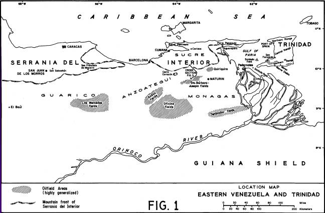
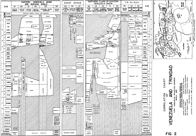
Our purpose in the present paper is not to give a complete account of the geosynclinal evolution but, within that context, to discuss specific problems in each country which can best be resolved by reference to the other. For a satisfactory depiction of the evolution of the Orinoco Geosyncline the reader is referred to Renz et al. (1958, p. 554-584, 1963, p. 102-l36, and accompanying figures). A generalized map (Fig. 1) is included here to show the interrelationship of Trinidad and Venezuela, and to indicate the location of places mentioned In the text. Relationships of the stratigraphic units mentioned are shown on a correlation chart (Fig. 2), which is based on a chart of multiple authorship prepared for the First Venezuelan Petroleum Congress in 1962. Descriptions of the units can mostly be found in the stratigraphic lexicons of Venezuela (Ministerio de Minas e Hidrocarburos, 1956) and Trinidad (Kugler, 1956): specific references are given for names introduced since 1956.
Suter (1951, p. 192) introduced the phrase “remnant formations” to describe distinctive rocks known a slump masses, boulder components of conglomerates, or tectonic wedges, but never encountered within normal sequences in Trinidad. Kugler (1953, p. 36-39) refers to some of these units and matches them against well known Cretaceous formations in Venezuela. Later the same author (Kugler, 1956, p. 53-55) has summarized them in thirteen categories. To a geologist familiar only with Trinidad, they are puzzling elements, but a Venezuelan geologist finds no difficulty in accepting these exotic blocks as remnants of familiar formations, shed southward from the rising borderland of the geosyncline.
Four broad groupings can be made, as follows:
(a) Organic‑detrital limestones of Barremian to Albian age These typify the El Cantíl Formation and, to a lesser extent, the Barranquín Formation (e.g. Morro Blanco Member) of eastern Venezuela. Their original status in the geosyncline was platform limestones, locally reefal, on the broad shelf extending north from the Guiana Shield to the edge of the deep trough (“tectogene” of authors) in which thick flysch deposits were accumulating.
(b) Dark, bituminous, siliceous limestones of Cenomanian to Senonian age. These represent the Guayuta Group of Venezuela, in which the Gautier and Naparima Hill formations of Trinidad could logically be included. They belong to the eugeosynclinal phase, when initial uplift of the northern borderland had formed an elongate trough in which euxinic facies were widespread.
(c) Fossiliferous glauconitic sandstones of shallow marine character and Maestrichtian age. Exact equivalents of these beds are not known in Venezuela. By inference they probably existed in what are now the mountains of Sucre and northern Monagas, but no late Cretaceous formations of the north flank of the geosyncline have escaped erosion there. Farther west, in the Guárico Mountains, no precisely similar beds are known, though the partly reefal Escorzonera Formation, in which beds rich in Actaeonella are now included, may be closely related. The Maestrichtian San Juan sandstones of the Anzoátegui‑Monagas foothills are almost completely barren and belong to the formational sequence of the stable south flank, which presumably contributed less to the exotic “remnant formations” than did the mobile north flank of the geosyncline,
(d) Fossiliferous limestones of Paleocene age. The best known example is the Soldado Formation which, because of its rich faunas of both mollusks and foraminifera, has become a classic reference point in Caribbean stratigraphy. Nevertheless its type section (Soldado Rock) is a large exotic block in the core of the Pedernales Diapir and the large mass of Soldado limestone at Marac is likewise rootless. Bolli (1952) concluded on purely faunal grounds that the Soldado limestone corresponds to the base of the Lizard Springs shales, but could present no lithostratigraphic evidence.
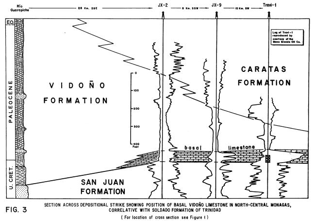
In eastern Venezuela limestones all but identical with the molluscan beds of the Soldado Formation are known in the subsurface of northern Monagas. They lie conformably in the base of the Paleocene Vidoño shales (an exact equivalent of the Lizard Springs shales of Trinidad) and above the Maestrichtian San Juan sandstones, Outcropping limestones at Cerro Corazón (Senn, 1940, p. 1580) are full of Venericardia planicosta‑group and probably belong to the same unit. Figure 3 is a representative cross section showing the status of this basal limestone member of the Vidoño Formation. Within the geosynclinal framework this unit marks the beginning of the Paleocene to Lower Eocene marine transgression over the gently sloping south flank.
In northern Guárico a completely separate development of fossiliferous Paleocene limestones exists. These are near‑reef beds surrounding the great reef‑limestone stacks which form the “morros” near San Juan de los Morros and San Sebastián. Larger foraminifera are their dominant faunal element. Their status in the geosyncline is demarcation of a narrow coastal shelf fringing the steep, unstable north flank. Boulders of similar, richly orbitoidal Paleocene limestones are well known as “remnants” in central Trinidad, especially in the Upper Eocene conglomerates.
It seems reasonable to conjecture that both the south-flank and north-flank Paleocene limestone facies, as known in Venezuela, extended eastward into the Trinidad area. Hence the known exotic blocks of such limestones in central Trinidad can be accounted for by slumping from a northern reefal province. The immense isolated masses of molluscan Soldado limestone farther south might more reasonably be derived from the south flank, first by sliding into the Rio Claro wildflysch beds in the mid-Miocene phase of orogenic instability, and later by uplift in diapiric structures rooted in these thixotropic beds (see Kugler, 1953, p. 51)
Formations of deep, open‑sea character, ranging from Upper Cretaceous to mid‑Miocene, are present in southernmost Trinidad. Only a hundred miles farther south the Precambrian basement rocks of the Guiana Shield are exposed, immediately south of the Orinoco Delta. On the reasonable assumption that the Shield is an ancient craton, a great wedge of Cretaceous‑Tertiary sediments must be postulated south of Trinidad, thinning and developing marginal to non‑marine facies towards the Shield. However, almost no clues exist in Trinidad as to the character and extent of the sedimentary units underlying this now‑drowned province.
Fortunately the blind area is on trend with the stable south flank of the geosyncline in Venezuela, where abundant geologic information is available as a result of intensive drilling for oil. Both depositional and structural trends there maintain a general E‑W to ENE‑WSW direction. Lateral changes are demonstrably gentle in the oilfield sectors, and no reason is seen for anticipating any abrupt change east of the limit of subsurface control. Consequently eastward extrapolation can be made fairly confidently from Venezuela into the sea‑covered area south of Trinidad.
The standard stratigraphic section in the Greater Oficina and Greater Temblador oilfields, from older to younger formations, starts with the Cretaceous Temblador Group resting unconformably on basement rocks. The basal beds are non-marine (Canoa Formation) but are followed by shallow marine beds of the Tigre Formation (Dusenbury, l960-a). It may be speculated that a late Cretaceous regression was followed by renewed marine invasion in Paleocene to Lower Eocene time. However, regional uplift at the end of the Middle Eocene led to deep erosion and peneplanation to levels within the Temblador Group or, to the south, the underlying basement.
Regional subsidence of the south flank started in the Upper Eocene, in epeirogenic fashion with no significant deformation, and continued gently until late Miocene time. The resulting southward transgression of the sea across the eroded shelf was slow, and the oldest transgressive beds in the Oficina‑Temblador sector are Oligo‑Miocene, namely the massive fluvio‑littoral sands of the Merecure Formation. These grade up into inner‑shelf facies (interbedded sands and shales) of the Oficina Formation, which in turn grade both upward and basinward into outer‑shelf shales of the Carapita, Freites and, in part, La Pica formations. In gross terms these formations form an enormous wedge in which thick basinal shales to the north grade into much thinner marginal marine beds to the south. Late in the Miocene the cycle became regressive, partly as a result of up‑tilting to the west, and the basin filled rapidly with marginal marine sands and shales (La Pica) followed by fluvio‑continental beds of the Las Piedras Formation.
In southern Trinidad, the formations corresponding to the Oligo‑Miocene transgressive phase described above are the Cipero, Lengua and lower Cruse. They are of much deeper character than their correlatives in Venezuela, and the Cipero in particular is a “Globigerina ooze” of abyssal character. It must be assumed that south of the present coast the Cipero marls grade laterally up-flank into medium depth shales of Carapita type, then a shale/sand sequence of Oficina type, and finally inshore massive sandstones of Merecure type. By extrapolation of known trends the zero line of this sedimentary wedge is placed under the Orinoco Delta. The deep marine Lengua shales must likewise pass transitionally southward into the somewhat shallower facies of the Freites Formation, which contains remarkably persistent sheet sands. An indication of this south ward shallowing is the presence in the Lengua of the Southern Range of limited microfaunas dominated by a few species of Uvigerina, Bolivina, Eponides and Robulus and sharply distinct from the highly diversified assemblages found in this formation farther north.
The regressive phase is mainly represented in Trinidad (also at Pedernales in Venezuela) by the Cruse-Forest sequence, largely composed of shallow marine shales with bar-type sands. However, in southeast Trinidad these beds merge into a thick “molasse” of paralic sediments (Moruga Formation) which seem to indicate an adjacent source area. Conjecturally a similar lateral transition exists south of the present coastline, but it must be noted that neither the Cruse-Forest nor the Moruga facies is known in the subsurface west of the geologically blind Delta region. There must also be an east-to-west transition into shalier beds of the Freites-La Pica sequence. It seems probable that a complex pattern of currents, controlled by the configuration of the basin, accounted for the different sand patterns in the partly correlative Freites, La Pica, Cruse-Forest and Moruga formations (see Barr et al., 1958).
The three most conspicuous structural trends in Trinidad are:
(a) the strongly parallel, asymmetric, thrust‑bounded folds trending WSW‑ENE across the island;
(b) the Los Bajos wrench fault in the southeast; and
(c) the rectilinear fault separation between metamorphic rocks of the Northern Range and flat‑lying Tertiary beds to the south
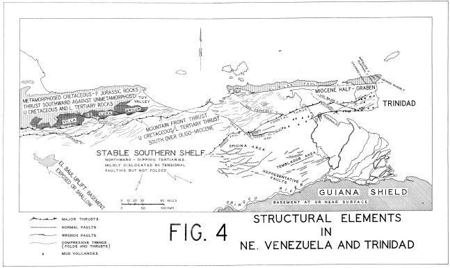
It should concern the geologist in Trinidad to know if these features are peculiar to the island, or if they form part of a broad regional pattern. The answers become clear when Trinidad is examined jointly with eastern Venezuela. The structural features mentioned in the text are depicted on Figure 4, which is based on the geologic-tectonic map at 1:1-million prepared for the First Venezuelan Petroleum Congress in 1962.
(a) The fold system of Trinidad is obviously symptomatic of compression from the north. Its exact counterpart exists in the Serranía del Interior of eastern Venezuela and can be traced westward for close to 500 miles. The compression resulted from the emergence and southward advance of the geosynclinal borderland, of which the mountains in question are the present‑day relic.
Detailed analysis of the geologic history of the borderland reveals that its growth was spasmodic. Phases of sudden uplift can be detected by unconformities within the borderland and by corresponding concentrations of coarse slumped deposits in the basinal deeps to the south. If any doubt existed that the compressive structures in Trinidad and Venezuela were related it would be dispelled by noting the synchronization of orogenic spasms, as tabulated [in] Table I [below]. From this and other evidence it is clear that northeastern Venezuela and Trinidad were
affected jointly by spasmodic compressional orogeny during Cretaceous to mid-Miocene time. However, there is a significant difference as regards the structure of the younger Tertiary formations. In Venezuela the post-Carapita formations (La Pica, Las Piedras) are not compressively deformed. They are warped into gentle folds and to some degree dislocated by normal faults, but the pattern can be explained by compaction without invoking external forces. In Trinidad, in contrast, the Cruse and Forest formations are deformed by asymmetric folding and reverse faults which, while more subdued, appear concordant with the structure of the older Tertiary formations (see Kugler, 1959). The obvious explanation is that the compressive stresses in the geosyncline persisted in Trinidad after they had died away to the west. A line of evidence which might support this concept is that the orogenic conglomerates in Venezuela become progressively younger from west to east (Guanape, El Pilar, Morichito[2]), suggesting that in some way the focus of intense deformation migrated slowly eastward.
There may, however, be a simpler explanation. As already noted, such deformation as affects the La Pica Formation in Venezuela is attributed to gradual compaction of the thick Carapita-La Pica shales in an asymmetric basin. Over pre-existing highs, such as the Tonoro-El Lirial axis, the beds are draped into anticlinal form. Parallel to the steep northern flank some down-to-basin normal faults have developed, typified by the Santa Bárbara Fault (see De Sisto, 1964). In Trinidad the basin was wider and deeper, filled by highly incompetent sediments (oozes, colloidal clays, thixotropic turbidites). Assuming an originally convex floor, the compaction of this great mass of plastic sediments would set up internal compression which could result in ornate, but essentially rootless, structures. The numerous diapirs and associated mud volcanoes of Trinidad may well reflect this type of deformation, and it is noteworthy that they extend only a short distance along the basinal axis into Venezuela.
The structural events of the late Tertiary deserve further critical analysis, as previous writers have given them an importance which the present writers consider exaggerated, Suter (1960, p. 72-75) extends the “Andean” orogeny into the Pliocene in Trinidad. Renz et al. (1958, p. 565; 1963, p. 116) state: “A still stronger deformation took place during late Miocene-Pliocene time when the entire Eastern Venezuela basin was affected by the tectonic stresses. In the northern mountain front, folding and faulting were so intense that Cretaceous rocks were overthrust to the south on Tertiary.” [3]
Table I. Chronology of Tertiary
Uplift Phases in the
Northern Borderland of the Orinoco Geosyncline
|
Time of orogenic
spasm |
Evidence in
Venezuela |
Evidence in Trinidad |
|
early Middle Miocene |
unconformity of La Pica on
Carapita; |
basal unconformity of Tamana to north; |
|
mid-Lower Miocene |
Cachipo turbidites interbedded
with axial Carapita shales; |
Herrera and Retrench turbidites within axial Cipero marls; |
|
early Lower Miocene |
slight unconformity in basal
Carapita; |
Nariva flysch and wildflysch; to north. |
|
end of Middle Eocene |
erosional hiatus below Peñas Blancas Formation, |
unconformity below San Fernando Formation; |
|
Paleocene |
Guárico flysch and wildflysch; |
Chaudiere flysch and wildflysch. |
In our opinion the Late Tertiary deformations—certainly in Venezuela and plausibly in Trinidad—can he attributed solely to mild epeirogenic tilt and differential compaction within an essential static and stable basin, hence application of terms such as “orogenetic phases” and “tectonic activity” has doubtful validity in this context.
Suter’s use (loc. cit.) of “Laramian” and “Andean” to describe the Cretaceous‑to‑Eocene and Oligocene‑to‑Pliocene orogenies in the Orinoco Geosyncline is difficult to justify. Firstly the twofold division is unnatural, as the spasmodic events belong to one prolonged orogeny. Secondly, the names themselves are of dubious significance “Laramian” (or “Laramide”) is derived from a prolonged orogeny in the Rocky Mountains, only related by coincidence of timing with the initial orogeny of the Orinoco Geosyncline. The Andes are a vast and complex mountain system, and it is misleading to pick on one phase of their growth as the Andean orogeny.
(b) A striking structural feature in southwest Trinidad is the Los Bajos wrench fault, which has a sharply defined right-lateral displacement of about 8 miles (Wilson, 1940, 1958). The Northern Range of Trinidad is transected by several faults with the same sense of movement (Chuparo, Platanal, Matelote, Grande Riviere and lesser faults). In Venezuela, also, sub-parallel wrench faults of the same type exist, including the Guaitoco, Guárico, Urica and San Francisco lineaments and others unnamed. Still another, the Soldado Fault, has been mapped by geophysical techniques in the Gulf of Paria. The fault traces are typically straight and run between NW-SE and WNW-ESE.
There seems little doubt that these wrench faults are a family produced by the same orogenic forces. Some authors have related them directly to the Cretaceous‑to‑Miocene geosynclinal orogeny, and it is an entirely reasonable concept that such dislocations would develop concomitantly with the thrust‑folds of the growing borderland. But this is not the whole story, as there is clear evidence that large horizontal displacements occurred after the compressive orogeny had died away. Specifically, along the southern half of the Urica Fault the horizontal displacement of gently dipping La Pica and lower Las Piedras beds is the same as that of highly disturbed Cretaceous and older Tertiary formations, in both cases about 5‑6 miles. This indicates that the principal movement took place in late Miocene to Pliocene time, Likewise, the Los Bajos Fault cuts cleanly through a sequence capped by young Pliocene beds.
The authors are of the opinion that the demonstrably young wrench faults represent response to torsional forces, which might be second‑ effects of' the Antillean Arc orogeny. It is entirely possible that some of the displacements followed the lines of transverse offsets developed in the older compressive orogeny, and that some such lineaments were not reactivated in late Tertiary time. For example, the San Francisco Fault displaces structures and facies provinces of Cretaceous to Eocene beds, but apparently does not displace the La Pica‑Las Piedras sequence and may, in fact, merge into the frontal thrust of the Monagas mountains.
(c) A final feature to mention is the rectilinear separation between the metamorphics of the Northern Range of Trinidad and the sedimentary beds to the south. This lineament is readily traced across the Gulf of Paria, running due east-west along the south side of the Paria Peninsula and on through the Cariaco Gulf. This fracture is named the El Pilar Fault, but is actually a zone or system of faults, with lateral offsets and other complexities. Because it is so straight for well over 200 miles, authors have tended to treat it as a major wrench fault but have not discussed the timing of the large horizontal displacements postulated (see Rod, 1956; Alberding, 1957). Neither in Venezuela nor Trinidad has any concrete evidence for large lateral movements been presented and, in fact, such evidence would be surprising, because the formations to the north and south of the fault zone are entirely distinct.
In northern Trinidad and across the Gulf of Paria into the small Yaguaraparo Embayment, pronounced down‑to‑south movement along the El Pilar Fault started in early Miocene time. The lunate half‑graben thus developed was largely filled with coarse detritus (Cunapo conglomerates) derived from the upfaulted block. Eventually late Miocene and Pliocene formations (Springvale‑Talparo and equivalents) overstepped the fault trace, indicating the end of down‑to‑south movement. These overstepping beds lie in undisturbed horizontal attitudes, indicating that any lateral displacement along the fault took place during or before the Miocene. Yet the Cretaceous to Miocene interval was marked by the development of a geosynclinal borderland, an evolutionary process to which lateral east‑west movements appear completely alien. No appreciable time interval is left unaccounted for, during which large lateral movements might have occurred and it therefore seems doubtful that the El Pilar Fault is, in any major sense, a wrench fault.
The present authors have conjectured that the El Pilar lineament may have originated as one of the oldest of the successive frontal thrusts of the geosynclinal borderland,. As such, it would establish a prominent fracture, verging on rectilinear which would be a line of preference for future dislocations. As the borderland emerged and expanded, tensional stresses would develop within it, and the Miocene half‑graben bounded by the El Pilar Fault in northern Trinidad may well reflect response to this condition. The Tuy‑Cariaco Basin, in which Mio‑Pliocene formations rest on eroded Cretaceous, is closely comparable. For an analogy, reference may be made to another part of Venezuela, namely the Mérida Andes. This is a block‑faulted uplift, along which crestal tension has led to the formation of “keystone grabens” bounded by long normal faults. Because of their straightness some of these (notably the Boconó Fault) have been described as major wrench faults although, as in the case of the El Pilar Fault, direct evidence of horizontal displacement is slight.
The foregoing examples have demonstrated, albeit briefly, how attention to Venezuela helps elucidate the geology of Trinidad. Next, to balance the picture, some cases are outlined in which evidence from Trinidad has greatly assisted the solution of problems in eastern Venezuela.
Nowadays the application of planktonic foraminifera to regional and interregional correlation is universally accepted. However, as little as ten years ago this branch of science was in its infancy. Its cradle was undoubtedly Trinidad, where rapid lateral changes of facies (e.g. Brasso/Nariva/Cipero) rendered benthonic foraminifera unsuitable for correlation and forced local paleontologists to rely on the planktonic forms.
In eastern Venezuela the Tertiary formations generally represent shallower facies than their correlatives in Trinidad, hence planktonic foraminifera are less conspicuous in the microfaunas. Furthermore, most of the formations have suffered diagenesis and induration as a result of compressive orogeny, hence foraminiferal preservation tends to be poor. It may be doubted that Venezuelan paleontologists, without external prompting, would have made special studies of the small planktonic species.
Fortunately, the Trinidad workers published several papers in 1944‑1948 which drew attention to the limited ranges of many species of the Globigerinidae, Globorotaliidae and their allies. As a result special search was made for these forms in Venezuela, and they led to solution of problems which had defied the application of other techniques. A few specific cases are:
(a) The Oligo‑Miocene Carapita Formation, as encountered in the subsurface of northern Monagas, is an immensely thick unit (perhaps as much as 20,000 feet) of uniform marine shales. It contains no persistent marker beds such as limestones, sandstones or glauconites, hence electric logs of the formation are featureless “railroad tracks” except where erratic turbidite sands are encountered. Though rich in benthonic foraminifera, the sequence of faunules in any given well reflects changes of facies and is completely misleading if used directly for correlation with other wells. When the planktonic foraminifera were eventually studied, the same zonal sequence as exists in the Cipero Formation of Trinidad was quickly recognized. On this basis the structural attitude of the formation could be deciphered and applied to prospecting for pre‑Carapita oilsands and solving various geologic problems.
(b) Over the years several interpretations of the deep‑seated structure below the Quiriquire oil field have been published. The latest shows an overturned syncline (Fig. 5‑A), very different from the faulted structures depicted earlier (Figs. 5‑B, ‑C) The revision rests directly on planktonic zonation of the Paleocene to Lower Miocene interval, by means of which hitherto unsuspected inversion of several well sections could be demonstrated.
(c) For many years correlation charts through the Serranía del Interior of northern Anzoátegui and Monagas showed a regional hiatus between Paleocene or early Eocene formations and the Upper Eocene Tinajitas limestones. Correlation of sparse pre-Tinajitas microfaunas with the planktonic zonation of Trinidad has gradually closed the gap, and continuous Paleocene to Miocene sedimentation is now accepted along the mountain-front belt (see Lamb, l964).
Such Miocene formations as crop out in northern Anzoátegui and Monagas represent only a small fraction of the great 'bulk of Miocene sediments in the basin. Furthermore they mainly represent the northwestern peripheral sector, and are dominated by non‑marine (Quiamare) and shallow marine (Capiricual, etc.) units. The limited outcrops of deep marine Carapita shales seem almost anomalous in the surface sequence, and give no hint of the bulk and importance of this formation in the subsurface farther east.
The reason for this paucity of Miocene exposures is that the upthrusted mountain‑front structures have largely been eroded down to Eocene and Cretaceous levels, while the down‑faulted basinal province, where Miocene formations have escaped erosion, is capped by the thick, flat‑lying Las Piedras and Mesa formations of Plio‑Pleistocene age. The result is that knowledge of the Miocene of the basin is largely derived from subsurface data—well cuttings and cores, electric logs, and seismograph records.
Density of drilling is sufficient that, by combining the lithologic and biostratigraphic data obtained from wells, reasonably detailed interpretations have been made of the age and depositional character of the subsurface Miocene units. Nevertheless the method is indirect, and it has been highly advantageous to Venezuelan geologists that close counterparts of the formations are exposed extensively in Trinidad. In particular, the Brasso Formation of the Central Range is a close equivalent of most of the Carapita Formation., and exhibits the same range of facies variants. The Herrera sands of Trinidad, although interbedded in the Cipero Formation, are genetically identical with the erratic turbidites (Cachipo Member) of the Carapita Formation. The Cruse and Forest formations, widely exposed across southern Trinidad, exemplify many of the sedimentational features of the equivalent La Pica Formation, which in eastern Venezuela is entirely confined to the subsurface.
The coastal mountains of Venezuela are mainly composed of metamorphic rocks of the Caracas Group. Age-diagnostic fossils, both megascopic and microscopic, are almost unknown. At a single locality Wolcott (1943) recorded poorly preserved mollusks among which Camptonectes sp. suggested Jurassic to Cretaceous age. Dusenbury and Wolcott (1949) claimed to record a Turonian microfauna, but later Dusenbury (1960-b) admitted to mis-identification and considered the material indeterminate. The only formation dated with confidence is the Maestrichtian Paracotos.
The metamorphosed character of these rocks contrasts strikingly with unaltered sediments of the Lower Cretaceous Sucre Group, which crops out in the adjacent belt to the south. The difference could feasibly reflect a much greater age for the Caracas Group. The presence of older Mesozoic or even Paleozoic rocks is plausible, in view of the existence of remnants of old formations on the south flank of the geosyncline—the Mireles Formation (Lower Ordovician) and the Hato Viejo and Carrizal formations (probably Jurassic).
Reference to Trinidad makes a Jurassic to Cretaceous age appear probable for the Caracas Group. The Northern Range is composed of a similar, though much thicker, sequence of metamorphic rocks known as the Caribbean Group (which, as originally defined, extended along the Paria and Araya peninsulas of north‑eastern Venezuela). Although far from abundant, sufficient fossil discoveries have been made in Trinidad to date the sequence with some accuracy. At widely separated levels (which attest to the steady subsidence and rapid deposition of this province), diagnostic faunas have been found of Upper Jurassic (Tithonian), Lower Cretaceous (Barremian and possibly younger) and Upper Cretaceous (Maestrichtian) age. Until evidence to the contrary may be found, it appears logical to treat the Caribbean and Caracas groups as correlative, even synonymous, and to date the Venezuelan formations on the basis of the Trinidad faunas. As a postscript, it may be mentioned that limestones from the Paria Peninsula have recently been studied in thin section and, by identification of foraminifera and other phyla, have been placed in the early Cretaceous interval.
In a classic example of shrewd observation and embracive interpretation, H. G. Kugler (1953) revolutionized interpretation of the geology of Trinidad by introducing the concept of extensive secondary deposition. His abstract starts with the simple statement: “It is suggested that many of the formerly assumed tectonic complexities of Trinidad are in reality the result of turbidity currents and submarine sliding and slumping.”
Previously the presence of enormous blocks of older rocks (many of them big enough to be quarried for tens of years, as at Marac, Morne Diablo and elsewhere), entirely surrounded by younger marine clays, was usually explained by remarkably localized thrusts and other tectonic complexities. Even more bizarre explanations were offered, such as Illing’s suggestion (1928, p. 19) that exotic pebbles were distributed by floating seaweed. Stainforth (1948, p. 1319) visualized periodic orogenic uplift along certain “labile belts” to account for lenses of shallow marine beds enveloped by archibenthic marls. Kugler swept away these untenable theories by recognizing the great exotic blocks as components of a “wildflysch” facies or as isolated slump masses. Hand in hand with recognition of the true nature of the blocks came understanding of less conspicuous features of an unstable, highly asymmetric basin. The Herrera sands, Interbedded with abyssal Cipero marls, were identified as turbidites. Basinal conglomerates such as the Río Claro Member were seen to he coarser turbidites, not genetically related to the transgressive conglomerates of a marginal marine province. Time gaps within seemingly continuous deep-water deposits could be explained by down-flank slumping, without invoking uplift and erosion.
Venezuelan geologists were not slow to realize that, if secondary deposits were so widespread in Trinidad, similar phenomena must exist in the western portion of the geosyncline Some specific examples recognized since Kugler pointed the way include:
(a) The Paleocene Guárico Formation is largely a thick flysch deposit. Its monotonous repetition of alternating sandy and shaly beds represents a succession of innumerable turbidites. Graded bedding is excellently displayed, and other sedimentary features typical of flysch deposits are well developed Trace fossils are abundant on the bedding planes.
(b) In parts of the Guárico Formation and in the Cretaceous Garrapata Formation there are impressive developments of wildflysch, in the form of great blocks of older formations scattered randomly in a clay matrix, The “morros” of Macaira are conspicuous stacks of Lower Cretaceous limestone weathered free from their softer Paleocene matrix in the Guárico wildflysch, as already conjectured by Kugler (1953, p. 42). The topographically similar, but even larger “morros” of San Juan are now regarded as Paleocene reefs essentially in their original position. However, nearby to the south a highly irregular fault pattern has been mapped to accommodate extensive outcrops of Cretaceous formations juxtaposed against Guárico flysch beds. It is entirely conceivable that this is a case of wildflysch on the grand scale, as known in Trinidad, and that the complex structures currently envisaged do not really exist.
(c) The Cachipo Member is defined and described in the paper presented at this conference by J.L. Lamb and J.A. Sulek (1965). It is a unit of turbidite sands embedded within the Carapita shales, closely comparable to the Herrera Member of the Cipero Formation in Trinidad. Recognition of its character has simplified understanding of the structure along the northern Monagas mountain front. The lenticularity of the sands is a normal feature of turbidites, hence no recourse need be made to faults arid unconformities to explain their absence.
It deserves emphasis that recognition of secondary deposition has provided a new tool for our attempts to reconstruct the history of the Orinoco Geosyncline. The presence of voluminous secondary deposits at certain levels is symptomatic of temporary instability of the north flank of the basin. Hence recognition of the true nature of the Garrapata, Guárico and Cachipo turbidites has been a key factor in dating phases of orogenic uplift (see Table I). Furthermore, identification of rock components in the coarser turbidites and slump blocks has revealed which formations were exposed to erosion in the mobile rim after each spasm of uplift.
It is suspected that eastern Venezuela contains one example of an allochthonous rock unit more spectacular than any known in Trinidad. This is the Villa de Cura Group, composed of metamorphic rocks which crop out extensively in the western sector of the Serranía del Interior (see Fig. 4). Their outcrop belt is 170 miles long and up to 20 miles wide, and these Villa de Cura rocks form a subsidiary mountain range in their own right. Nevertheless it has proved impossible to accept them as an autochthonous element in the stratigraphic sequence of the Serranía. The most recent studies (mostly unpublished theses of the Princeton Caribbean Research Project) postulate that the entire Villa de Cura Group is a gigantic allochthon which slid into its present area from a former high region north of the existing coastline.
ALBERDING, H., 1957 “Applications of principles of wrench‑fault tectonics of Moody and Hill to northern South America.” Geol. Soc. Am., Bull., vol. 68, p. 785‑790
BARR, K.W., WAITE, S.T. & WILSON, C.C., 1958 “The mode of oil occurrence in the Miocene of southern Trinidad, B.W.I.” Am. Ass. Petr. Geol., Symposium : “Habitat of oil” p. 535‑550
BOLLI, H.M., 1952 Note on the Cretaceous‑Tertiary boundary in Trinidad, Jour. Pal., vol. 26, no. 4, p. 669‑675
DE SISTO, J., 1964 “The Santa Bárbara fault of northern Monagas” Asoc. Ven. Geol. Min. Petr., Bol. Inf. vol. 7 no. 4, p. 99‑110
DUSENBURY, A.N., 1960‑a “The stratigraphy of the Cretaceous Temblador Group of the Eastern Venezuela Basin.” Asoc. Ven. Geol. Min. Petr., Bol. Inf., vol. 3, no. 9, 246‑257
—, 1960‑b. “Revision of the microfauna described from the Cretaceous metamorphics in Quebrada Yaguapa, eastern Miranda.” Asoc. Ven. Geol. Min. Petr., Bol. Inf., vol. 5, no,. 11, p.316‑517
DUSENBURY, A.N. & WOLCOTT, P.P., 1949 'Rocas metamórficas cretácicas en la Cordillera de la Costa, Venezuela.” Asoc. Ven. Geol. Min. Petr, Bol., vol. 1, no, 1, p. 17‑26
FIRST VENEZUELAN PETROLEUM CONGRESS, 1962 (= Primer Congreso Venezolano de Petróleo) see under: Sociedad Venezolana de Ingenieros de Petróleo.
ILLING, V.C., 1928 “Geology of the Naparima region of Trinidad (British West Indies).” Geol. Soc. London, Quart. Jour., vol. 84., pt. 1, p. 1‑56
Lamb, J.L., 1964 “The geology and paleontology of the Río Aragua surface section, Serranía del Interior, State of Monagas, Venezuela.” Asoc. Ven. Geol. Min. Petr., Bol. Inf., vol. 7, no. 1, p. 111‑123
— & DE SISTO, J., 1963 “The Morichito Formation of northern Monagas.” Asoc. Ven. Geol. Min. Petr., Bol. Inf., vol. 6, no. 9. p. 269‑276
— & SULEK, J.A., 1965 “Miocene turbidites in the Carapita Formation of eastern Venezuela.” 4th Carib. Geol. Conf. (preprint)
LIDDLE, R.A., 1928 “The geology of Venezuela and Trinidad (1st. edn.). Fort Worth, Texas
—, 1946 “The geology of Venezuela and Trinidad” (2nd edn.). Pal. Res. Inst., Ithaca, N.Y.
KUGLER, H.G., 1953 “Jurassic to recent sedimentary environments in Trinidad.” Ass. Suisse Géol. Ing. Pétr., Bull., vol. 20, no. 59, p. 27‑60
—, 1956 “Trinidad.” Lexique Stratigraphique International vol. 5, fasc. 2b, Amérique Latine
—, 1959 (1961) Geological map of Trinidad and Geological sections through Trinidad (1:100,000). Orell Füssli S.A., Zürich and E. Stanford Ltd., London
MINISTERIO DE MINAS E HIDROCARBUROS, 1956 “StratigraphIcal Lexicon of Venezuela,” (also in Spanish). Dirección de Geología, Bol. Geol., Spec. Publ., no. 1
RENZ, H.H., ALBERDING, H., DALLMUS, K.F., PATTERSON, J.M., ROBIE, R.H., WEISBORD, N.E. & MASVALL, J., 1956 “The Eastern Venezuelan Basin.” Am. Ass. Petr. Geol., Symposium: “Habitat of oil,” p. 551-600
—, 1963 “La cuenca oriental de Venezuela.” Soc. Ven. Ing. Petr., “Aspectos de la industria petrolera en Venezuela”, p. 100‑189 (see below)
ROD, E., 1956 “Strike‑slip faults of northern Venezuela. Am. Ass. Petr. Geol., Bull., vol. 40, no. 3, p. 457‑476.
SENN, A., 1940 “Paleogene of Barbados and its bearing on history and structure of Antillean‑Caribbean region.” Am. Ass. Petr. Geol., Bull., vol. 24, no. 9, p. 1548‑16l0
SOCIEDAD VENEZOLANA DE INGENIEROS DE PETROLEO, 1963 “Aspectos de la industria petrolera en Venezuela” and Mapa geológico‑tectónico del norte de Venezuela (1:1,000,000) (Both these works were products of the First Venezuelan Petroleum Congress held in Caracas in March, 1962)
STAINFORTH, R.M., 1948 “Description, correlation, and paleoecology of Tertiary Cipero Marl Formation, Trinidad, B.W.I.” Am. Ass. Petr. Geol., Bull., vol. 32, no, 7, p. 1292-1330
SUTER, H.H., 1951‑1952 “The general and economic geology of Trinidad B.W.I.” Colonial Geol. and Min. Res., vol. 2, nos. 3,4; vol. 3, no. 1.
SUTER, H.H., 1960 “The general and economic geology of Trinidad, B.W.I,” Second edition with revisionary appendix by G.E. Higgins. H.M. Stationery Office, London
WILSON, C.C., 1940 “Los Bajos Fault of south Trinidad, B.W.I.” Am. Ass. Petr. Geol., Bull., vol. 24, no. 12, p. 2102‑2125
—, 1958 “The Los Bajos Fault and its relation to Trinidad's oilfield structures.” Inst. Petr., Jour., vol. 44, no. 413, p. 124‑136
WOLCOTT, P.P., 1943 “Fossils from metamorphic rocks of Coast Range of Venezuela.” Am. Ass. Petr. Geol., Bull., vol. 27, no. 12, p. 1632.
[1] The term “Orinoco Geosyncline”, apparently introduced by Liddle (1928, 1946), is employed here in preference to the more frequently used “Eastern Venezuela Geosyncline”, which is open to confusion with the structural basin as it exists today.
[2] For a definition and description of the Morichito Formation, see Lamb and De Sisto, 1964.
[3] This second statement is considered erroneous, and arises from mis-correlation of the upper Quiamare Formation (involved in mountain-front structures) with the basinal La Pica Formation: compare figures 3, 4, 13 of Renz et al. with Figure 2 of this paper.